
Got Tree Data?
You have a full set of land cover data, canopy data, maps, and reports. What’s next?
January 15, 2020 | Carrie Asselmeier
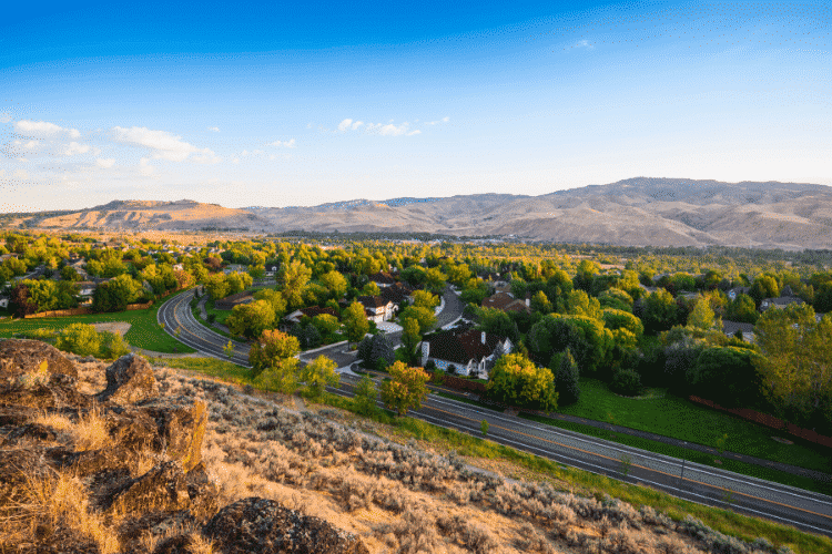
An urban tree canopy assessment has been completed for your city, you have a full set of land cover data, canopy data, maps, and reports. What’s next?
Many recognize the benefits of trees like improvement of stormwater quality, air quality, energy conservation, wildlife habitat, health benefits, and as well as economic benefits. Urban tree canopy assessments are the first step. What happens next with tree canopy and other data from assessments ranges from recognition of new canopy goals, tree planting priorities, and implementation of forestry management plans. In some cases, urban tree canopy assessments lead to more robust initiatives and networks for collaboration to inform the sustainable development of cities and their canopy.
Urban Forestry Collaboration
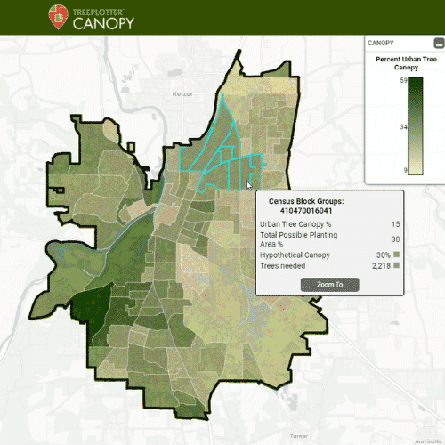
A great example of this collaboration is the Treasure Valley Canopy Network. In 2013, PlanIT Geo partnered with the Idaho Department of Lands and communities in Idaho’s Treasure Valley to conduct an urban tree canopy assessment and create geospatial tools to help planners and managers strategically manage their urban forest. With the tree canopy data, land cover layers, and tools acquired from this assessment as their backbone, the Idaho Department of Lands partnered with The Keystone Concept to create the vision, mission, and platform for what eventually became the Treasure Valley Canopy Network.
Public, Private, and Nonprofit
The Network is a collaborative of public, private, and non-profit professionals who serve communities by collaborating on projects and programs that build, maintain, and enhance the urban infrastructure of this rapidly growing region. The Network uses a “Map the Canopy” interactive map through ArcGIS Online that was created from the urban tree canopy data from the 2013 PlanIT Geo™ assessment. The map is used by partners, planners/managers, landowners, and more to view their communities’ tree canopy and engage with the Network. These resources and maps help support the goals of the Network, to collaborate and inform sustainable development of the Treasure Urban tree canopy assessments can also be a stepping stone for other research. Key program growth areas for the Network over the last 2 years include urban heat island research, the Treasure Valley Shade Tree project which partners with Idaho Power, Idaho Department of Lands, and the Arbor Day Foundation’s Energy-Saving Trees Program, and a City Forest Credits project and program. The kind of collaboration that the Treasure Valley Canopy Network has built, is what PlanIT Geo hopes other cities can achieve using urban tree canopy assessments.
We must collaborate, innovate and sustain to support the health of our urban forests, green infrastructure and the surrounding communities

Collaborate, Innovate, and Sustain
As the Treasure Valley Canopy Network mission statement says, “We must collaborate, innovate and sustain to support the health of our urban forests, green infrastructure, and the surrounding communities.” Learn more and engage with the Network on their various social media platforms.
Related Resources

How To Set Effective, Evidence-Based Urban Tree Canopy Goals
Urban tree canopy goals must walk a careful line of ambition, inspiration, and practicality. To encourage well-informed canopy cover goals we have assembled some best practices to help communities find the right target for them.

A Holistic Approach to Urban Forestry
It has been a goal at PlanIT Geo to incorporate more than one of our services into projects with a holistic approach and to develop a full circle story of urban forests around the country.
Get Your Urban Tree Canopy Assessment TOMORROW
We are the first in our industry to provide 60-cm resolution land cover data built into an interactive tree canopy software tool, making it simple for you to view, plan and achieve your tree canopy goals. Off-the-shelf tree canopy analysis for the lower 48 is already completed.

How to Leverage Your Tree Canopy Data
Tree canopy assessments provide detailed data to perform a variety of next steps. In this on-demand webinar, you will hear from past clients how they leveraged their tree canopy data.
Stay Up To Date With The Latest News and Events
Join Our Community
Stay informed on the urban forestry industry with our monthly TREEbune newsletter, live webinars, and industry-specific content delivered to your inbox.
Urban Forestry Webinars
PlanIT Geo has a substantial on-demand webinar library. Get CEU credits, grow your knowledge base, and stay current on cutting edge industry technology.
Follow Us
We love to share industry-related news, software tutorials, blogs, and company news across our social channels.
Stay Up To Date With The Latest News and Events
Join Our Newsletter
Stay informed on the urban forestry industry with our monthly TREEbune newsletter, live webinars, and industry-specific content delivered to your inbox.
Urban Forestry Webinars
PlanIT Geo has a substantial on-demand webinar library. Get CEU credits, grow your knowledge base, and stay current on cutting edge industry technology.
Follow Us
We love to share industry-related news, software tutorials, blogs, and company news across our social channels.