Advantages of a Statewide Tree Inventory
Learn how statewide applications are developed and leveraged through three examples: New Mexico, Wisconsin, and Oregon
July 5, 2024 | Alec Sabatini
To manage public trees you need to know what you have, where it is, and what condition it is in. The most effective way to answer those questions is with an on-the-ground tree inventory. This holds true at any scale; from a single city park to an entire state.
Several states have partnered with PlanIT Geo™ to create a hub for collecting, standardizing, and analyzing local inventories in a statewide TreePlotter™ app. These tools have proved to be much greater than the sum of their parts. A statewide tree inventory app is not only a tool for guiding state-level decisions, it’s a resource to help communities to complete their own inventories and learn from each other.
Below we’ll explore how statewide applications are developed and leveraged through three examples: New Mexico, Wisconsin, and Oregon. Urban tree canopy assessments can also take a statewide perspective and we’ll showcase Florida’s newly launched TreePlotter CANOPY tool at the end.
New Mexico Statewide Tree Inventory
Except for a few large cities, most communities in New Mexico have little to no budget for urban forest programs. One of the main objectives of the state’s Urban and Community Forestry Program is to help communities build their own programs, often from the ground up. In a resource-limited state, they’ve learned networking and information sharing are some of the greatest ways they can provide support.
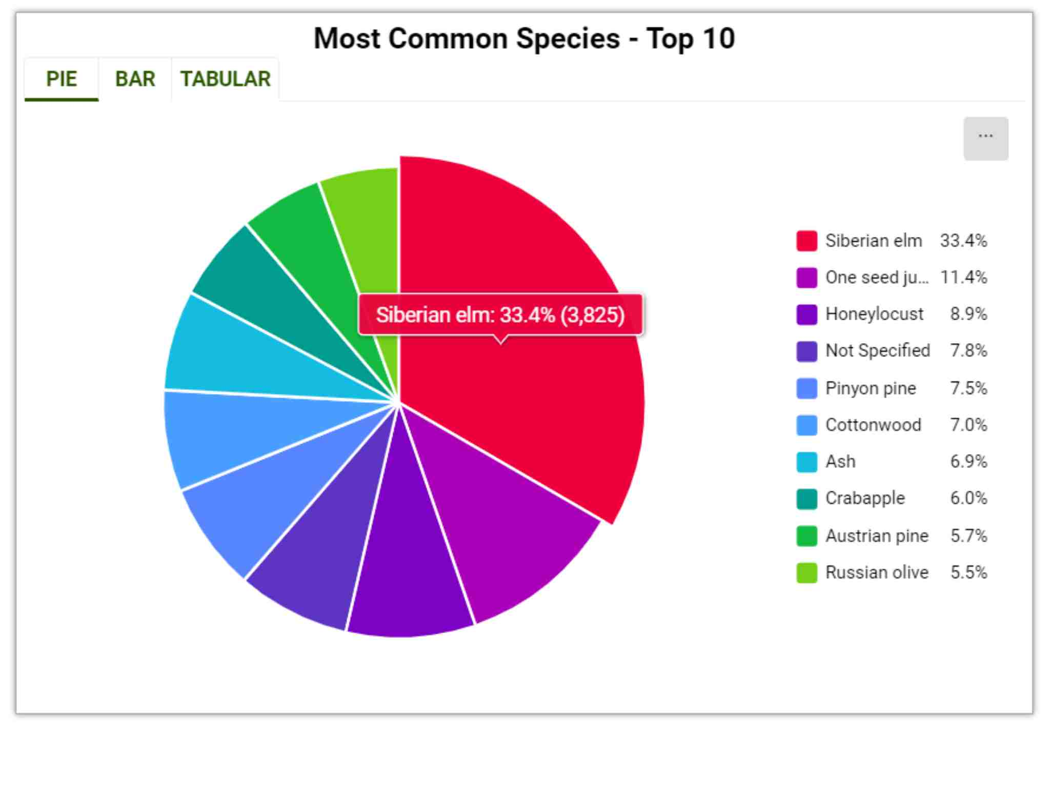
New Mexico launched a statewide TreePlotter application to be a nexus for local and state staff to put heads together and learn from each other’s failures and successes. So far 43 governments and organizations have uploaded 24,465 trees. This helps spotlight widespread trends, like a major monoculture of Siberian Elm trees.
At Right: Top 10 most common tree species on New Mexico’s statewide tree inventory.
Climate change is a major concern and many communities around the state are experiencing an enormous loss of older trees. “If we want trees in our cities in the future, we will have to be very deliberate about selecting species, placement, and care,” says Shannon Atencio, New Mexico State Forestry, Las Vegas District. The statewide tree inventory is a resource for tracking species survivability and guiding climate-smart tree selections.
The New Mexico Urban and Community Forestry Program offers grants for tree inventories and can also provide communities with free TreePlotter access. “A tree inventory is a crucial tool when asking the city government to spend money on trees,” says Shannon. “In most cases, one is not dealing with biologists and natural resource specialists. Charts and maps showing risk are a straightforward tool to show the urgency of the public safety problem. It also helps leadership understand the scale of funding required to mitigate the risk.”
Wisconsin Statewide Tree Inventory
Wisconsin’s statewide urban tree inventory may very well be the best in the nation. Since 2014, the Urban Forests program at the Wisconsin Department of Natural Resources (DNR) has developed a three-pronged approach for urban forest assessments, including the aggregation of tree inventories into the Wisconsin Community Tree Map.
Since starting with TreePlotter in 2016, the Wisconsin DNR has compiled over 1 million trees from 219 different organizations! Their robust grant program has funded community tree inventories for over 30 years. In the last few years, the Wisconsin DNR has required that any community using grant funds for a tree inventory collect a minimum baseline of attributes.
As the Urban Forest Assessment Specialist at Wisconsin DNR, Dan Buckler manages this motherload of urban forestry data. Dan highly recommends other states require certain attributes while staying mindful to not overburden communities with too many requirements. Though it takes some preparation, having uniform data makes it a breeze for Dan to run analyses, answer questions, and identify trends for local and statewide projects.
Communities don’t exist in a bubble. A state application allows you to see trends across more than just a city. You can look at species diversity at the metropolitan scale, not just within the municipality. Climate change works across boundaries, so having tree data, in a unified format, across boundaries helps.
-Dan Buckler, Urban Forest Assessment Specialist, Wisconsin DNR
For example, a few years ago there were reports of male cultivars of Amur corktree fruiting. Researchers ran a quick species filter to identify all 830 Amur corktrees statewide to design an observation plan. Dan also frequently helps local companies forecast wood reuse opportunities. By filtering for poor condition, large diameter trees, companies can get a preview of the upcoming wood supply.
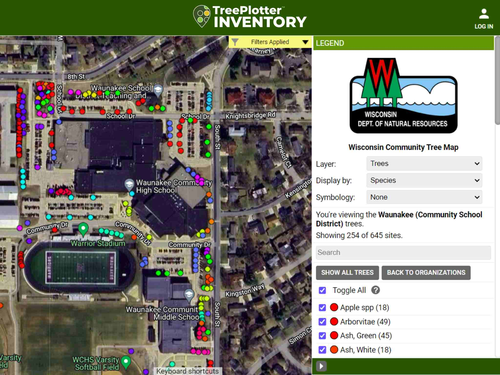
One of the greatest advantages for communities is storytelling support. The tree statistics, and especially ecosystem benefits, build buy-in from government leadership and strengthen budget requests. The community tree map is also a great public engagement tool. Over 44 schools, districts, and college campuses have added their trees to Wisconsin’s inventory. The Wisconsin DNR helps schools incorporate the tree inventory into their curriculums, seeding the next generation of urban forest advocates.
Above: Trees inventoried by Waunakee Community High School biology students on the Wisconsin Community Tree Map.
Oregon Statewide Tree Inventory
The Oregon Department of Forestry (ODF) wants to help communities maximize the benefits of their urban forest while minimizing costs and liabilities. Scott Altenhoff, ODF’s Urban and Community Forestry Assistance Program Manager, knows their mission can’t succeed without first understanding what communities have, what they want, and then monitoring progress.
“Our job is to advise municipalities and organizations on how to do more with less. I’m convinced information is the best way to do that, and I can’t think of a better source of information on trees, people, and their relationship than TreePlotter.”
Oregon’s statewide tree inventory has compiled 210,000 trees from 50 different community partners and counting. Some of these communities use TreePlotter, but ODF also imports data from a range of different software platforms, depending on the community’s setup.
Tree inventories are not only valuable for knowing what communities have, but in the case of a wildfire, knowing what has been lost. An updated tree inventory goes a long way in getting the maximum tree loss compensation from FEMA. In 2020 a wildfire tore through the Town of Talent, Oregon, destroying approximately 40% of the city and 1 in 4 urban trees. They didn’t have a definitive tree inventory then, but have since utilized ODF urban forestry grants to access TreePlotter and inventory almost 3,000 street and park trees.
Statewide Canopy Assessments
A tree inventory tells part of the urban forest story, and an urban tree canopy assessment helps inform the rest of the picture. Whether it’s a tree inventory or an urban tree canopy assessment, communities face many of the same barriers to getting updated data: not enough staff, budget, expertise, and/or time.
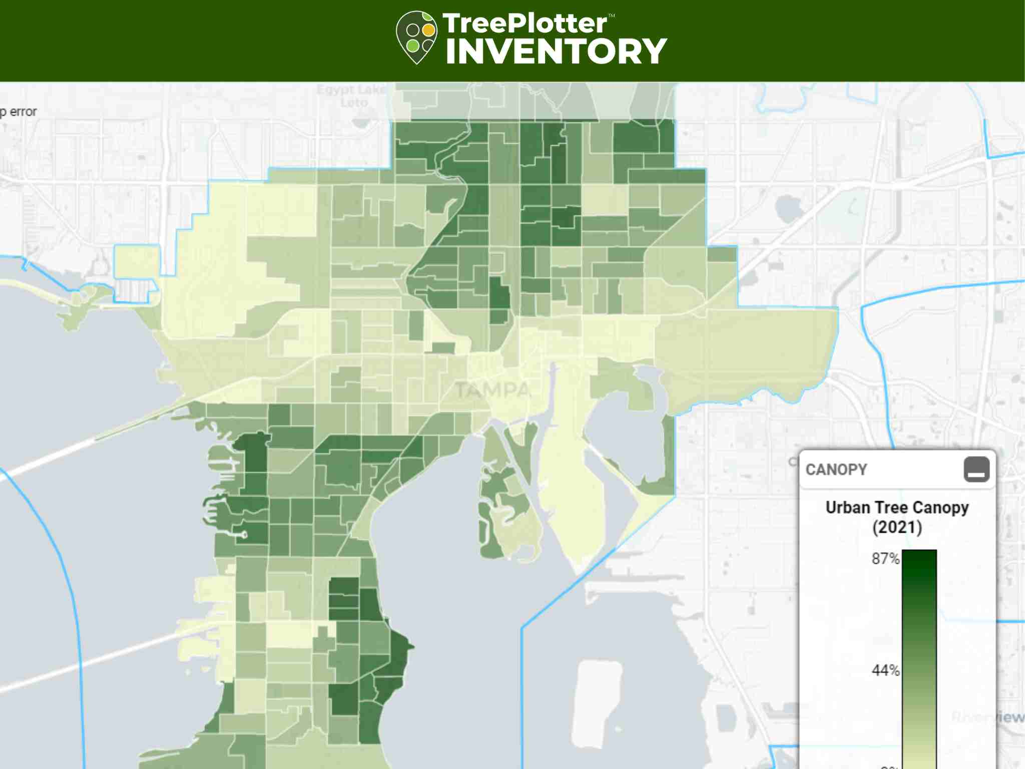
A statewide canopy assessment lowers those barriers, giving less-resourced communities a free opportunity to look at their trees from the top down. In 2023, Florida’s Urban and Community Forestry program partnered with PlanIT Geo to create a resource communities could use to guide their own urban forest management. The result was an assessment of urban tree canopy, possible planting areas, and tree canopy change for 488 Florida cities and towns.
The findings of the assessment are available on the Florida Forest Service TreePlotter application. Communities can use TreePlotter’s built-in tools to identify areas with low canopy and high planting potential, fine-tune priorities based on a range of metrics, and evaluate new canopy goals. State and regional coordinators also get invaluable insights on broader canopy trends and can adjust funding and programs accordingly.
Above: Florida’s statewide application showing urban tree canopy in Tampa.
Work With the Big Picture
To learn more about the statewide tree inventories of Wisconsin and Oregon, check out this excellent webinar with Scott and Dan. You can also get an in-depth look at the statewide Florida canopy tool in this webinar with Todd Little, the Urban and Community Forestry Program Coordinator with the Florida Forest Service.
Curious about how a tree inventory or canopy application could work for your state, county, or municipality? We’d be happy to have a conversation specific to your needs and goals. Please reach out with any questions here.
Related Resources
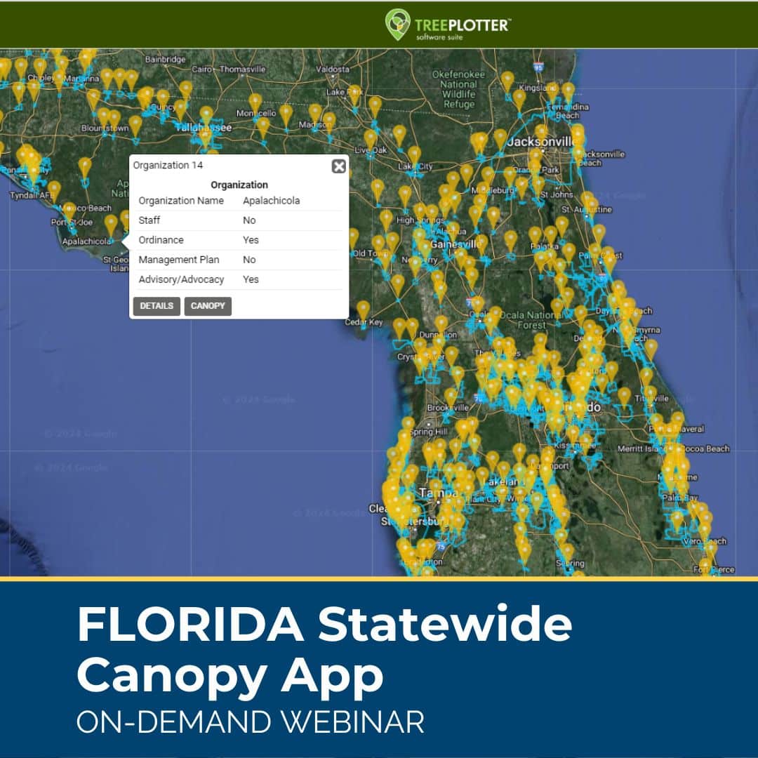
Florida Statewide Tree Canopy App
ON-DEMAND WEBINAR: An incredible, free urban forest resource is now available to Florida communities: an urban tree canopy assessment of 488 Florida cities, towns, and Census Designated Places. See how communities can freely view and analyze the canopy results of their community on an interactive web application.
Urban Forestry and Heat Mitigation 101: Free Guide
This guide covers opportunities at the intersection of urban forestry and heat mitigation, including the fundamentals of urban heat, methods to measure heat and tree canopy, and urban forest strategies for heat mitigation.
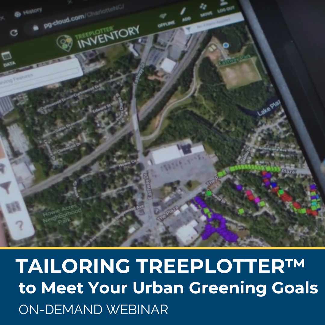
Managing Your Urban Forest From a Statewide View
ON-DEMAND WEBINAR: Statewide tree inventories provide a unique scale for tracking and managing urban forests. By centralizing dozens of community tree inventories in one place urban forest managers can identify larger, regional trends and make more informed decisions, such as how species diversity looks at the metropolitan level, not just the municipality scale.
Learn how statewide inventories in Oregon and Wisconsin guide high-level state management decisions and empower individual communities, how their statewide inventories are launched, and the benefits and challenges of creating these massive datasets.
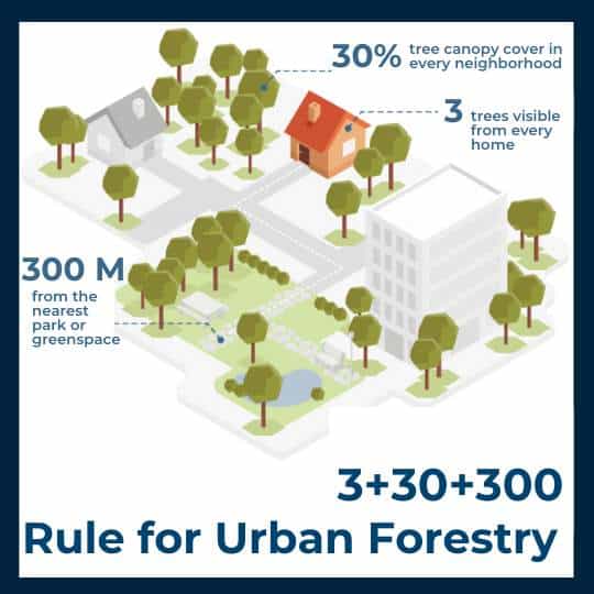
Urban Forestry’s New Benchmark: The 3+30+300 Rule
In 2021 Cecil Konijnendijk, Director at the Nature Based Solutions Institute, proposed a new guideline for greener, healthier, more resilient cities: the 3+30+300 rule. The rule sets three minimum criteria for urban trees and green space: At least 3 trees in sight from every home, school, and workplace, At least 30% tree canopy in every neighborhood, and No more than 300 meters between every home and the nearest park or green space. Learn more in this blog post.
Stay Up To Date With The Latest News and Events
Join Our Community
Stay informed on the urban forestry industry with our monthly TREEbune newsletter, live webinars, and industry-specific content delivered to your inbox.
Urban Forestry Webinars
PlanIT Geo has a substantial on-demand webinar library. Get CEU credits, grow your knowledge base, and stay current on cutting edge industry technology.
Follow Us
We love to share industry-related news, software tutorials, blogs, and company news across our social channels.
Stay Up To Date With The Latest News and Events
Join Our Newsletter
Stay informed on the urban forestry industry with our monthly TREEbune newsletter, live webinars, and industry-specific content delivered to your inbox.
Urban Forestry Webinars
PlanIT Geo has a substantial on-demand webinar library. Get CEU credits, grow your knowledge base, and stay current on cutting edge industry technology.
Follow Us
We love to share industry-related news, software tutorials, blogs, and company news across our social channels.

