Grant Guide: California IRA Urban Forestry Grants
Key details on California’s IRA grants and the role urban forestry software can play
April 10, 2024 | Alec Sabatini

The next two months are packed with potential for California urban forests. An unprecedented $30.8 million is available for urban forestry projects through the California Inflation Reduction Act (IRA) Grants. Organizations and local governments have the opportunity to win funding for projects where they are needed most: disadvantaged and under-invested urban communities.
If you represent one of the eligible applicants, don’t miss this chance! The application deadline is May 30th. This blog will break down key details of the application process, with a particular focus on the role urban forestry software can play in strengthening your application and eventually, supporting your project. When you’re ready to dive into the process, check out the most up-to-date grant guidelines on the CAL FIRE website to get started.
Key Details of the California IRA Urban Forestry Grants
The grant program timeline:
- Applications are due by May 30th, 2024 at 5pm PDT
- Awards will be announced in June and July, 2024
- All project work must be completed by March 31st, 2028
Eligible applicants:
- Local governments (city, county, qualifying districts)
- Nonprofit organizations
- Federally recognized Tribal Nations
- School districts, community college districts, and childcare facilities
- Special districts, such as park, recreation, water, and local taxing districts
The eligible applicants depend on the grant type. I’ll provide a short breakdown of the grant types below. Refer to page 24 of the grant guidelines to see the full grant type details.
Applications will be submitted on the CAL FIRE’s eCivis Grants Portal, and an accompanying user guide for the portal can be found here. You do not need an account on SAM.gov to submit a grant application, but an active account is required to receive grant funds. The registration process can take up to a couple of weeks to become active, so it’s worth starting while working on your application.

Six Grant Project Types
Urban Forest Expansion and Improvement
Urban tree planting, maintenance, and associated vegetation to provide multiple benefits, tree and plant establishment care, and planting site preparation.
Urban Forest Management Activities
Establishment or updating of a tree inventory, urban forest mapping and analysis, and/or long-term management plans.
Urban Forest Education and Workforce Development
Creation, development, and implementation of projects to educate, train, and employ individuals to prepare them for careers in urban forestry.
Urban Forest Regional or Statewide Impact
Improvement, expansion, and coordination of urban forestry programs throughout a large geographic area or statewide. Must employ multiple strategies listed in the other grant types.
Urban Forest Equity Capacity Building
Support external or partnering entities in securing project implementation funds from CAL FIRE, reporting on grant activities, and/or providing the expertise needed to implement projects.
Green Schoolyards
Assist with planning and/or implementing projects that focus on tree planting, extreme heat, environmental, economic, and social benefits for urban public school campuses and eligible childcare facilities.
Grant awards range from $150,000 to $1.5 million for all grant types except for Urban Forest Regional or Statewide Impact, which has a larger maximum of $3 million.
No Match Requirements
The purpose of these grants are to support disadvantaged and low-income urban communities in growing equitable access to trees and their benefits. All grant projects must deliver 100% of program benefits to these communities. To lower the barrier to accessing these grant funds, cost share and match requirements are waived for all awards. I’ll repeat it: don’t miss the chance to apply!
Identifying Priority Populations
Eligible areas for these grants include state-designated priority populations, disadvantaged communities, low-income communities, and/or low-income households. This blog will use priority population to refer collectively to these designations. An additional requirement is communities must contain at least 2,500 people.
Three mapping tools are suggested for demonstrating, on a census tract basis, how a proposed urban forest project will directly benefit a priority population.
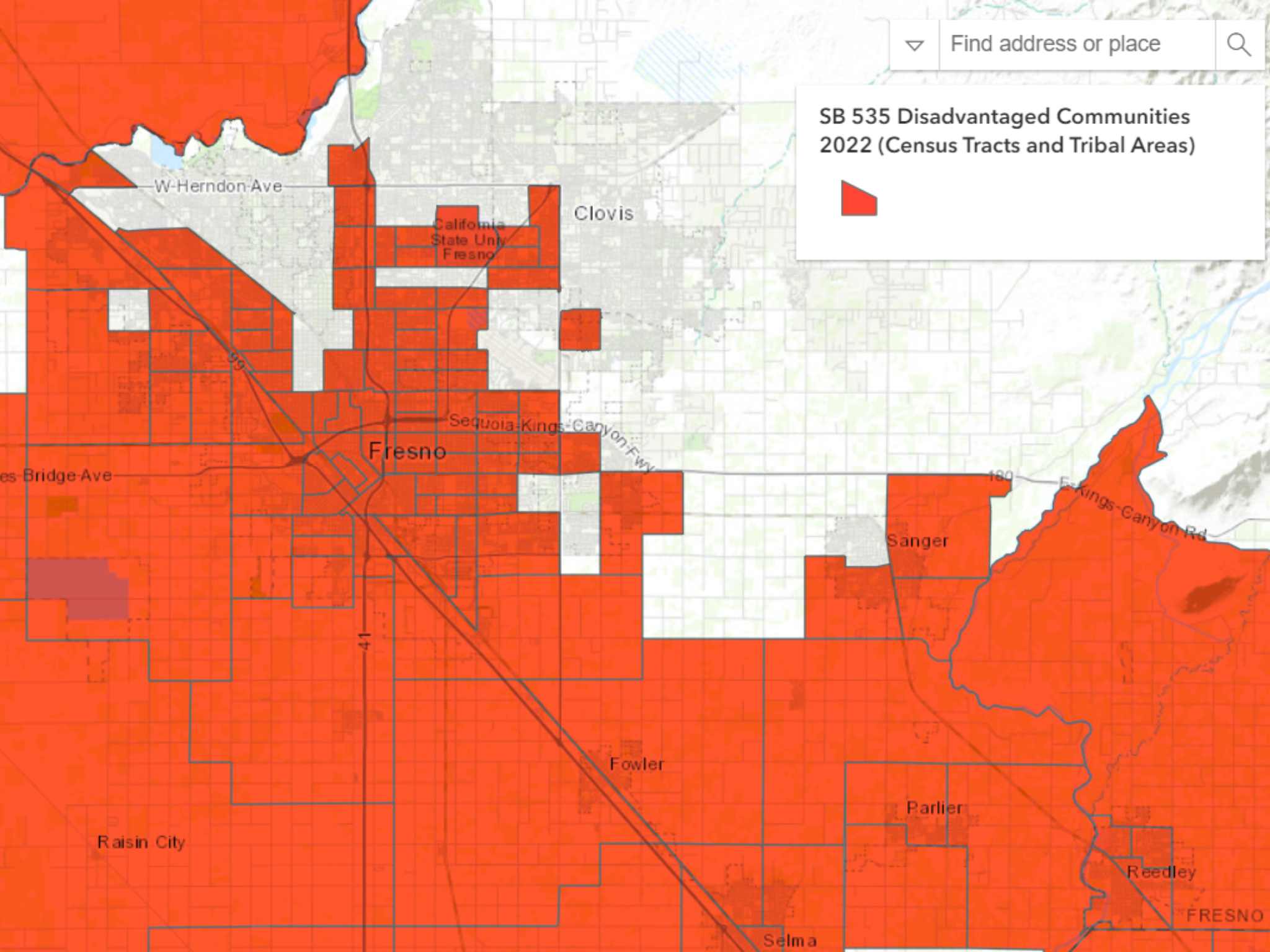
CalEnviroScreen 4.0
CalEnviroScreen is a screening tool used to help identify communities disproportionately burdened by pollution. Applicants should look specifically at the SB 535 Disadvantaged Communities map, which highlights the highest-scoring census tracts and tribal areas, which are eligible areas for California IRA Urban Forestry grants.
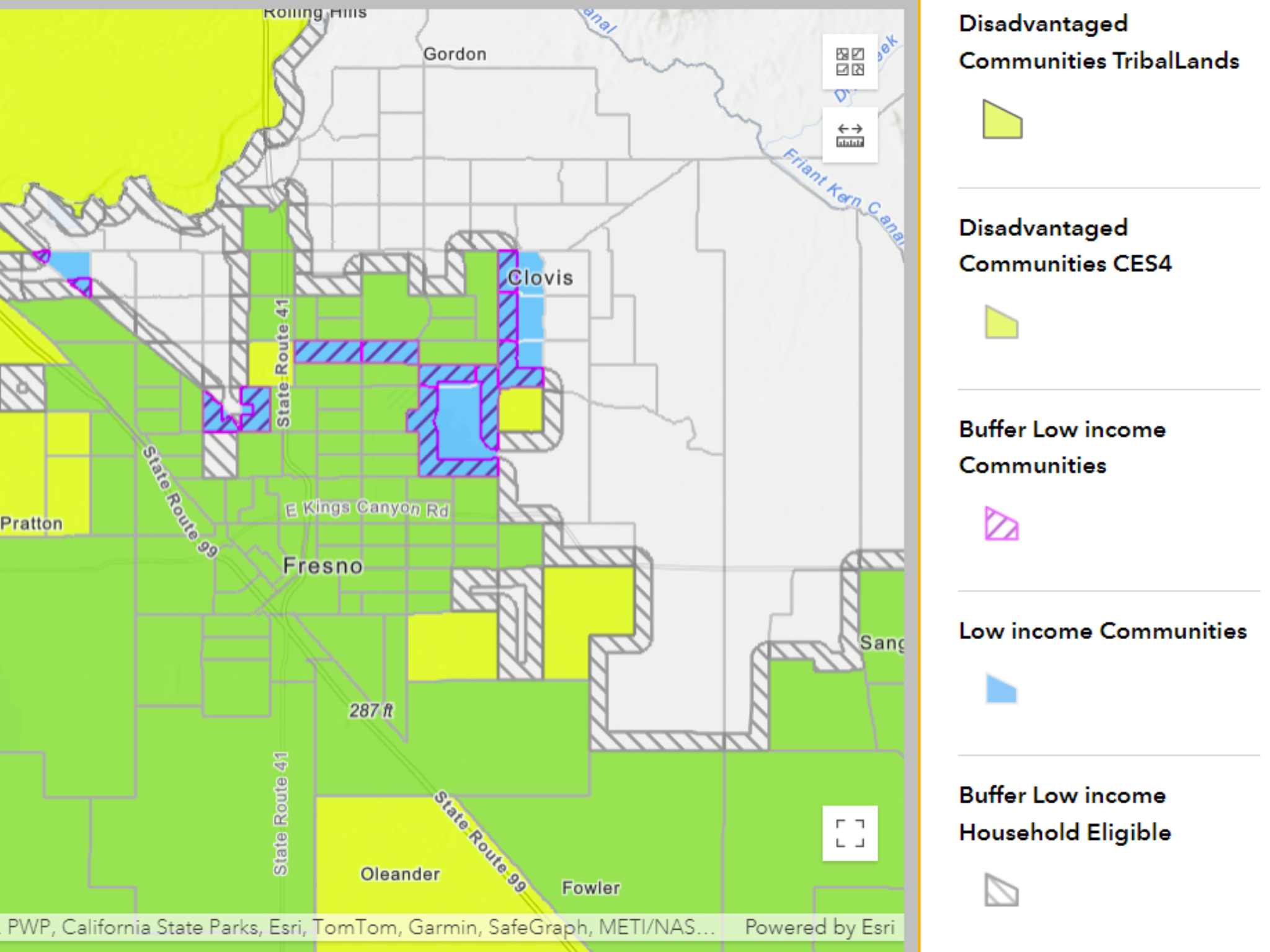
California Climate Investments Priority Populations
The California Climate Investments Priority Populations mapping tool shows disadvantaged communities and low-income communities as defined by California Climate Investments, both of which are eligible areas for California IRA Urban Forestry grants. Since this tool shows both disadvantaged and low-income communities, it’s a good tool to start with. .
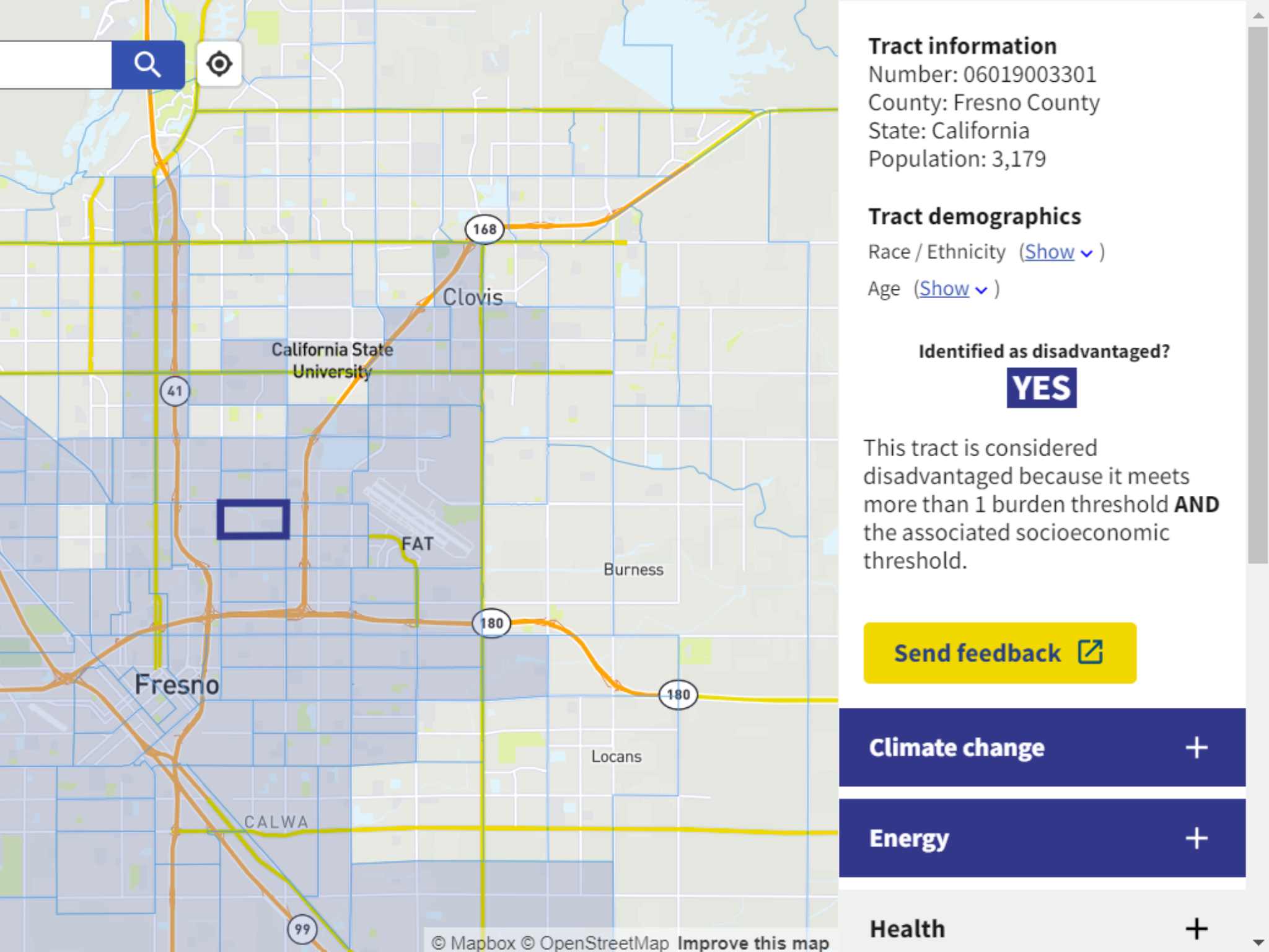
Climate and Economic Justice Screening Tool (CEJST)
The nationwide Climate and Economic Justice Screening Tool (CEJST) was developed by the White House Council on Environmental Quality to highlight overburdened and underserved census tracts, which are eligible areas for California IRA Urban Forestry grants. PlanIT Geo is in the process of adding a new data layer to TreePlotter™ INVENTORY to show CEJST disadvantaged community boundaries. This layer is expected to launch in the next couple of months, making it much simpler to view and filter trees plotted within disadvantaged census tracts.
Give Your Organization Some Back Up With Urban Forestry Software
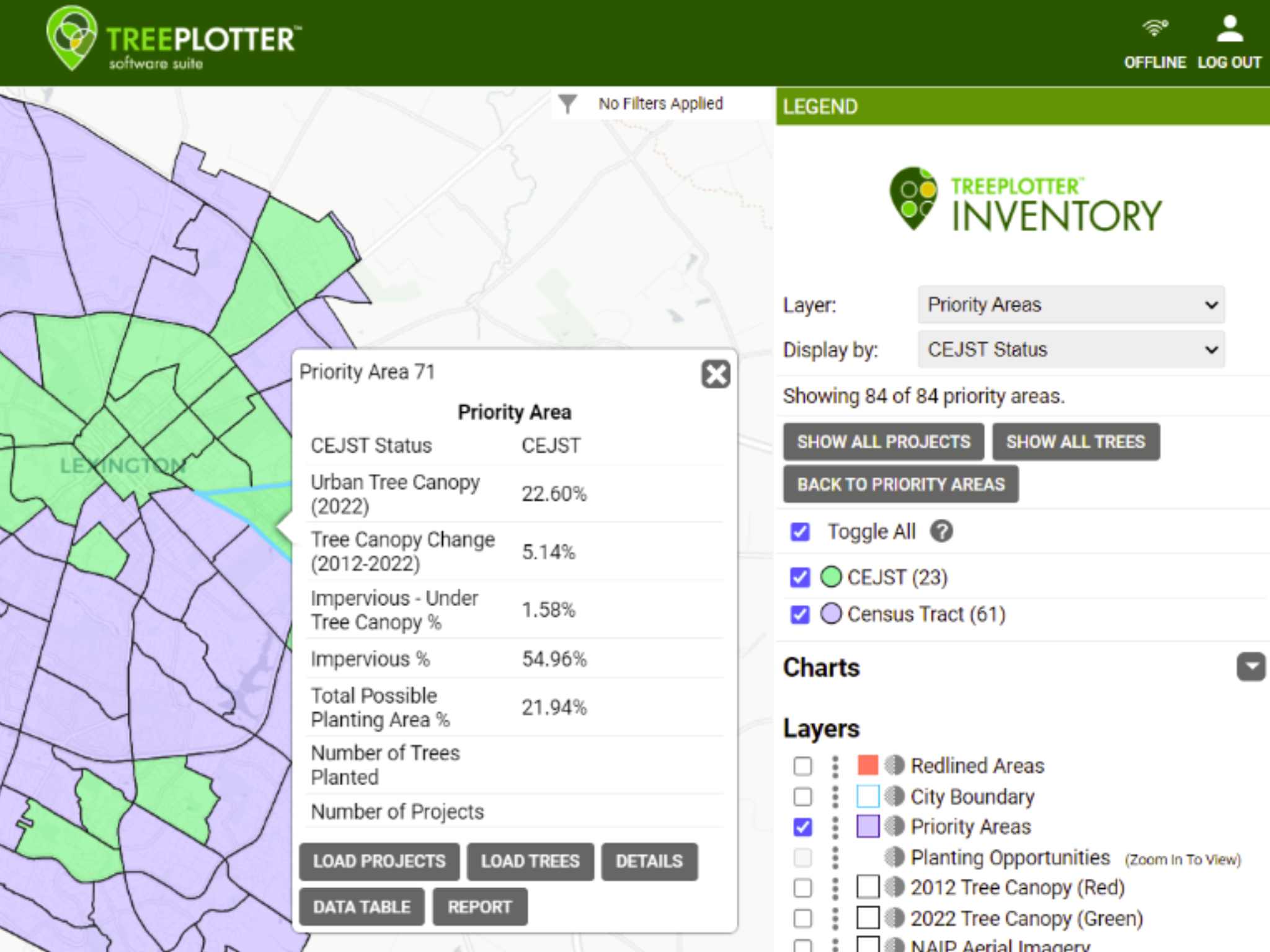
Example of upcoming CEJST data layer in TreePlotter INVENTORY.
We’ve seen a misconception pop up that software is not an eligible expense under IRA Grants. This is false. Software is not considered equipment and is therefore not subject to the $5,000 unit expenditure cap. Depending on the delivery, grantees can show software acquisition as a supply cost, or a contractual cost if there are ongoing costs for subscription access, data collection, etc. For example, your organization could apply for a 3-year subscription to TreePlotter INVENTORY as a contractual cost.
Tracking the progress of your project at the census tract level is essential for this grant. Using products like TreePlotter INVENTORY, a GIS tree management software, makes it simple to track exactly where your grant dollars are going and measure their impact.
Streamlined Reporting
Any organization intending to plant trees using grant funds must report a list of data attributes for each planting, such as scientific name, ownership type, latitude, and longitude, priority population status, tree stock size, and much more. With TreePlotter INVENTORY, you can customize your data fields to align with the grant requirements, keeping all the necessary data at your fingertips come reporting time.
Similarly, the grant guidelines require tree maintenance to be tracked and reported. INVENTORY makes it a breeze to track maintenance. The Work Records and Work History features make it easy to log tree work in the field and run periodic reports to track what’s been done. The grant guidelines also state special attention should be given to the ecosystem benefits. With the Ecosystem Benefits module, you can get estimates on your trees’ carbon, air quality, and stormwater impacts backed by the latest i-Tree research.
Simply put, GIS tree management software helps keep your grant project laser-focused on the areas most in need and important questions about your operations can be answered in just a few clicks.
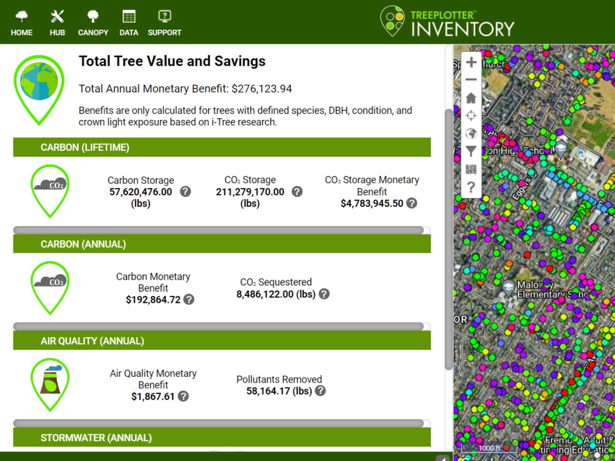
Ecosystem benefit display in TreePlotter INVENTORY for Fremont, California.
Putting Inventory Data to Work
For organizations interested in conducting or updating a tree inventory through the Urban Forest Management grant type, GIS tree software is a must. Yes, it’s necessary for tracking the data during the inventory, but the real kicker is how to leverage that data once it’s collected.
TreePlotter INVENTORY has a suite of functions designed to help organizations turn inventory data into action. It’s helpful for picking planting sites and for prioritizing maintenance or removal of trees. Removing trees has special requirements that require the approval of the CAL FIRE Regional Urban Forester, and INVENTORY makes it easy to provide the necessary photos and information for any removal requests.
PlanIT Geo provides TreePlotter INVENTORY to California Releaf. Nonprofits that are members of the Releaf network have the opportunity to utilize INVENTORY through that network. If interested, please reach out to California Releaf.
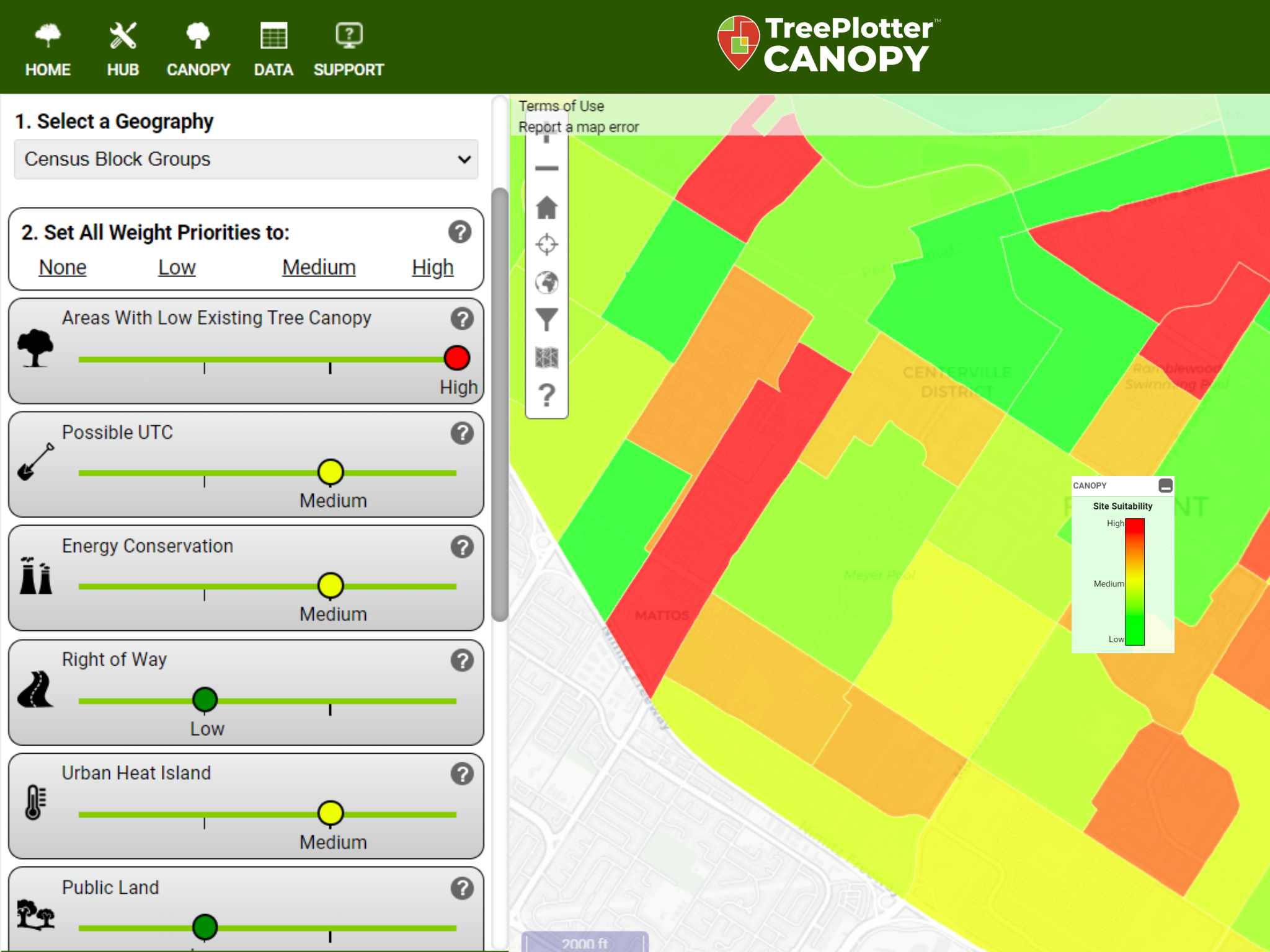
The planting prioritization tool within TreePlotter CANOPY.
Urban Tree Canopy Mapping
This grant is also an excellent opportunity to obtain urban tree canopy data and analysis software. The mapping tools referenced above are just a start. With a tool like TreePlotter™ CANOPY, you can overlay similar demographic information with land cover data to precisely identify where your organization should focus its efforts.
A core component of this grant is to sustain or grow urban tree canopy. With TreePlotter CANOPY you can establish a clear baseline canopy amount and track growth and loss every couple of years as new aerial imagery becomes available. CANOPY allows your organization to see where all of the available planting space exists within a community, and then filter data based on census tracts or other metrics like urban heat island potential to build carefully prioritized planting plans.
Urban tree canopy data is a powerful storytelling tool for earning additional funding beyond the California IRA urban forestry grants. An urban tree canopy assessment can tell a compelling visual story of the urban forest. Having maps and data documenting exactly how tree cover is changing and how it is distributed across a city moves conversations into a discussion of reality instead of hypotheticals.
This Grant Is A Seed
These grants, with no match requirement, are a low-barrier jumpstart for organizations to significantly amplify their impact with disadvantaged communities.
An optimal urban forestry program is built on four pillars: an updated tree inventory, a recent tree canopy assessment, effective tree ordinances or codes, and an urban forest management plan. This grant can be used to develop one or more of those pillars to set up effective urban forest management for decades to come in the neighborhoods that need it most.
We’d be happy to have a conversation specific to your community and grant application. Please reach out with any questions about how software, an inventory, a canopy assessment, or management planning could support your project.
Related Resources
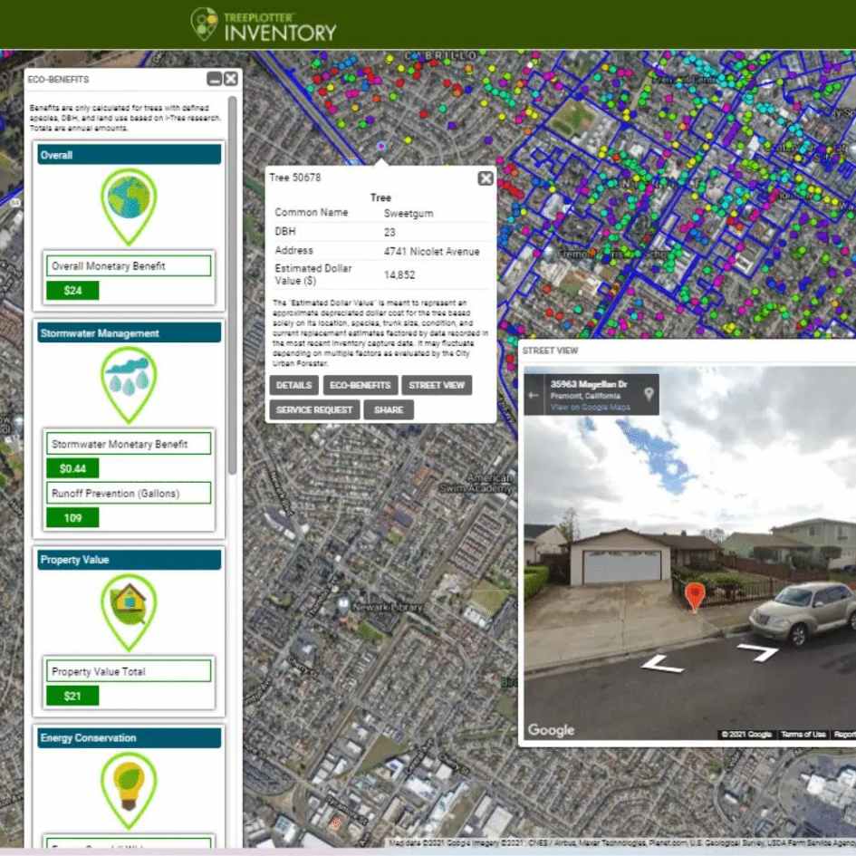
Tree Inventory: Fremont, CA
Explore the tree inventory data and view it in Fremont’s own TreePlotter app . We determined the state, characteristics, and trends of the City’s urban forest. Analyses and summaries were completed for the inventoried trees to determine the health and diversity of the trees in the City.

On-Demand Webinar: How to Prepare Shovel Ready Projects
Are you poised to take advantage of incoming funding opportunities from states and regranting organizations? Now is the time to prepare so that shovels can hit the dirt as soon as money hits the bank account.
Blog Post: Plant For the Future With A Sister Climate City Analysis
It requires careful planning to select trees that will thrive in the expected climate conditions in the future.We developed a new method called the Sister Climate City Analysis to model the future climate of Fremont, CA with a real world example. This is a crucial challenge for any city so we decided to break down the information needed to identify tree species that have the best chance of benefiting cities for generations to come.

Guide: Urban Forestry and Heat Mitigation 101
We are not yet one quarter into what promises to be a very hot century, and the consequences are deadly. This guide covers opportunities at the intersection of urban forestry and heat mitigation, including the fundamentals of urban heat, methods to measure heat and tree canopy, and urban forest strategies for heat mitigation.
Stay Up To Date With The Latest News and Events
Join Our Community
Stay informed on the urban forestry industry with our monthly TREEbune newsletter, live webinars, and industry-specific content delivered to your inbox.
Urban Forestry Webinars
PlanIT Geo has a substantial on-demand webinar library. Get CEU credits, grow your knowledge base, and stay current on cutting edge industry technology.
Follow Us
We love to share industry-related news, software tutorials, blogs, and company news across our social channels.
Stay Up To Date With The Latest News and Events
Join Our Newsletter
Stay informed on the urban forestry industry with our monthly TREEbune newsletter, live webinars, and industry-specific content delivered to your inbox.
Urban Forestry Webinars
PlanIT Geo has a substantial on-demand webinar library. Get CEU credits, grow your knowledge base, and stay current on cutting edge industry technology.
Follow Us
We love to share industry-related news, software tutorials, blogs, and company news across our social channels.
