Analyzing and Monitoring Tree Canopy Data: A Strategy for Sustainable and Equitable Urban Forests
Monitoring tree canopy is more than just counting the number of trees

Monitoring urban tree canopy is more than just counting the number of trees; it’s about shaping healthier, greener, and more equitable cities. With urbanization on the rise, keeping a close eye on tree canopy data is crucial for ensuring urban forestry programs deliver benefits such as improved air quality, biodiversity, and community well-being. Regularly analyzing this data every two years allows cities to align urban forestry goals with real-time needs, while also addressing environmental justice issues.
In this post, we’ll explore how regular urban tree canopy assessments can support sustainable urban forestry, and how TreePlotter CANOPY software empowers communities with the tools to make smarter, data-driven decisions.
Why Are We Monitoring Tree Canopy Data Every Two Years?
Urban forests are dynamic ecosystems—trees grow, environments change, and so do the city’s needs. Monitoring tree canopy data every two years offers critical insights into how well a city’s urban forestry efforts align with sustainability goals. This assessment cycle enables:
- Adjustments to strategies for planting and maintenance
- Identifying gaps in current tree canopy, particularly in underserved neighborhoods
- Tracking the health of trees and identify emerging threats
- Proactive responses to ensure urban forests continue to thrive
Tools That Simplify Data Analysis
The thought of manually and regularly analyzing urban tree canopy data is overwhelming, but with the right equipment the process becomes streamlined. PlanIT Geo’s TreePlotter CANOPY software was developed to help municipalities monitor and analyze canopy coverage in real-time with features to offer a comprehensive view of a city’s urban forest, from current canopy coverage to areas that need additional tree planting, without a GIS background.
CANOPY goes beyond merely tracking trees; it helps cities meet larger goals, such as enhancing climate resilience and improving tree equity. With its intuitive interface and customizable features, users can easily visualize trends, identify planting opportunities, and ensure tree canopy growth aligns with long-term sustainability plans.
Enhancing Urban Forest Planning with the LCTE Data Pack
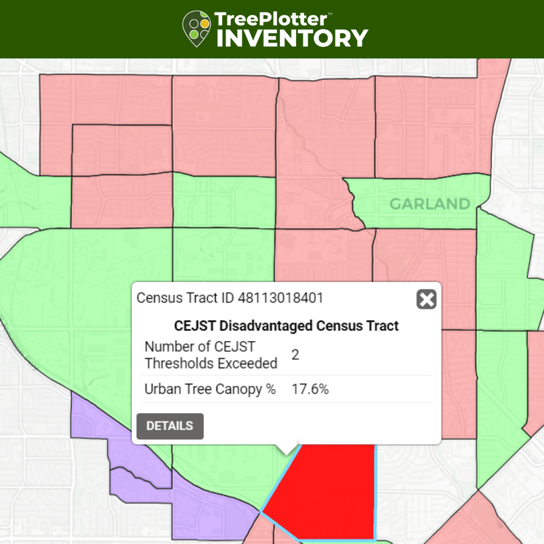
While monitoring tree canopy data is critical, it’s also important to consider equity in urban forest planning, and our new Land Cover and Tree Equity (LCTE) Data Pack does just that. This powerful add-on to TreePlotter CANOPY provides additional data layers on disadvantaged communities and historical redlining areas (where available), which are key to planning equitable urban forest projects2.
An early adopter of the LCTE Data Pack is the City of Garland, Texas, which received a $1 million grant from the USDA Forest Service to expand tree canopy in underserved neighborhoods. With the LCTE Data Pack, Garland’s parks staff can now prioritize tree planting in areas identified by the Climate and Economic Justice Screening Tool (CEJST).


I can pull up [within TreePlotter] how many trees we planted in each census block and calculate the ecosystem benefits. We can show these specific areas will increase canopy by X amount, have improved climate resilience, and show how those benefits create a return on investment
-Matt Grubisich, City of Garland Parks Director
Monitoring Tree Canopy and Turning Data Into Action
Having access to up-to-date urban tree canopy data is just the beginning.
The real value lies in using the data to inform decisions that benefit the entire community. For instance, after reviewing its TreePlotter CANOPY data the City of Charlotte was able to prioritize planting in neighborhoods with the lowest tree coverage, helping to improve tree equity and environmental justice.
Similarly, Garland plans to use its canopy and equity data to tell a compelling story of how its $1 million USD grant directly benefited disadvantaged communities. By tracking every tree planted and its condition over time, the city will ensure compliance with grant requirements and demonstrate how increased canopy cover leads to better climate resilience and public health outcomes.
A Long-Term Vision for Urban Forests
An Urban tree canopy assessment is not just about addressing immediate needs; its about planning for the future. By committing to analyzing and monitoring tree canopy data every two years, cities ensure urban forests grow sustainably and provide benefits for generations to come. With powerful tools like TreePlotter CANOPY and the LCTE Data Pack, cities are better equipped to meet urban forestry goals, address environmental justice issues, and create greener, healthier communities.
Ready to take the next step in monitoring tree canopy and advancing urban forest equity? Learn more about how TreePlotter CANOPY can support your city’s goals by exploring PlanIT Geo’s TreePlotter software suite.
Related Resources

Tree Inventory Planning for Actionable Data
Not all tree inventories are created equal. All tree inventories include some type of assessment of trees in a defined area, but they vary widely in scope, execution, and cost. A well-planned tree inventory answers a community’s top urban forestry questions and provides the maximum information return for the capital available.

New Data for Equitable Urban Planning
In this On-Demand webinar we Explore a new data offering in TreePlotter, the Land Cover and Tree Equity (LCTE) Data Pack. Communities, especially IRA grant winners and future applicants, must carefully plan and track how their projects benefit disadvantaged areas.

Cultivating Tree Advocates on City Council
Urban forestry programs often operate on tight budgets and urban forest managers must continually advocate for funding from internal and external sources. Having a supportive mayor, city council member, county commissioner, division supervisor, or any other role with sway over budgets and priorities, can make a huge difference in getting the staff and resources needed to grow a healthy urban forest.

What We Can Learn from Charlotte’s Urban Forest
Charlotte has won the top prize on the Husqvarna Urban Green Space Index (HUGSI) for two years running. By a multitude of metrics, Charlotte has a world class urban forest. In this eBook we explore what exactly the city has been doing so well when it comes to urban forest management.
Stay Up To Date With The Latest News and Events
Join Our Community
Stay informed on the urban forestry industry with our monthly TREEbune newsletter, live webinars, and industry-specific content delivered to your inbox.
Urban Forestry Webinars
PlanIT Geo has a substantial on-demand webinar library. Get CEU credits, grow your knowledge base, and stay current on cutting edge industry technology.
Follow Us
We love to share industry-related news, software tutorials, blogs, and company news across our social channels.
Stay Up To Date With The Latest News and Events
Join Our Newsletter
Stay informed on the urban forestry industry with our monthly TREEbune newsletter, live webinars, and industry-specific content delivered to your inbox.
Urban Forestry Webinars
PlanIT Geo has a substantial on-demand webinar library. Get CEU credits, grow your knowledge base, and stay current on cutting edge industry technology.
Follow Us
We love to share industry-related news, software tutorials, blogs, and company news across our social channels.
